07 Mar 2016
First repeat photography in the Torres del Paine National Park
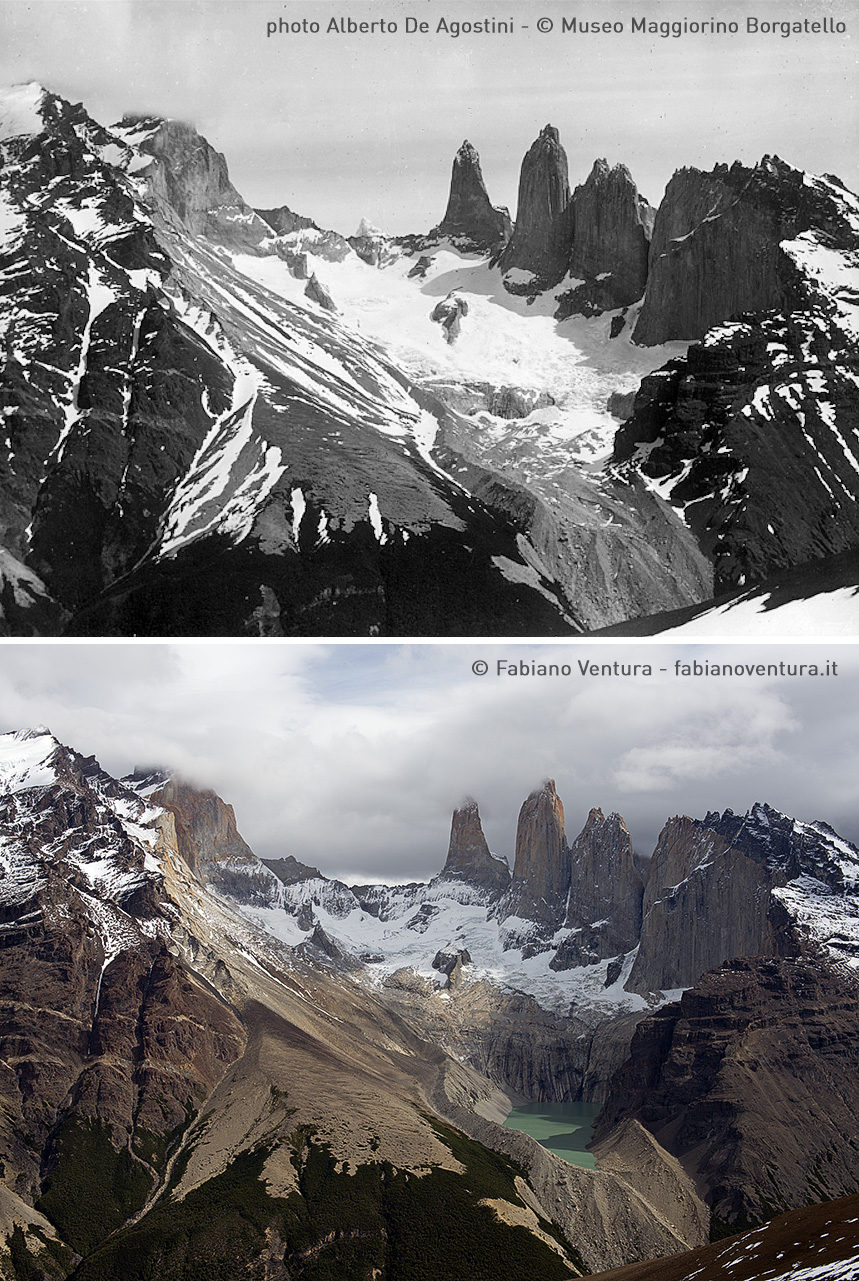
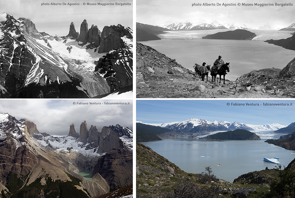
February 21st – we are now getting into the heart of the expedition in the Torri del Paine National Park in Chile, drawing up initial plans to find the exact spots where Alberto De Agostino took his photographs of the park’s glaciers. I was here in 2005 and can clearly remember that there was once a glacier where now all I see is a valley and a large lake. This convinces me that a simple comparison of archive images with shots taken now will have a powerful visual impact.
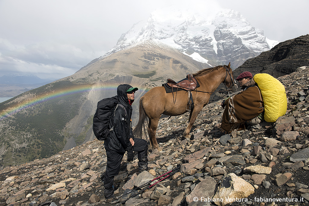
We ride off on horses provided by “Hotel Las Torres”, regardless of the heavy rain and strong wind buffeting the lower valley. After climbing 500 metres in altitude the gradient becomes even steeper and the horses’ hooves begin to slip. It takes all the effort we can muster to convince them to continue the climb. After a few stumbles we come to the end of the woods and decide to continue the ascent on foot. Miguel, our horseman, stays with the horses while I continue the climb on my own with my heavy backpack.
Once I reach the Mount Paine pass, blasts of wind that must be over 120km per hour force me to lay low. I struggle to arrive just below the peak and take shelter behind a boulder and decide to leave my backpack and all my equipment there, given that with these weather conditions rule out the idea of taking photographs. I continue the tough ascent, bearing in mind that I will need to retrace my steps with my equipment.
After comparing the archive image with the surrounding landscape I am convinced that it was taken from the summit, which means I have to continue climbing.
At two in the afternoon, after walking along a long snow-capped ridge, I reach the peak and find the expect spot where the photograph was taken. The clouds blowing in from the ocean threaten rain and I decide to begin the descent before the weather gets any worse.
I try to call Miguel on the radio in the hope that he is still waiting with the horses as it would be exhausting to walk back to the valley with a 15kg backpack – but at this altitude I am out of range. I descend the valley and at last manage to reach Miguel, who was there waiting for me. By 6pm we are back at the stables. It was a backbreaking climb, but I am happy to have found the exact spot where I need to take the shot. I will be back there in the coming days!
The weather forecast is so bad that we have to wait down in the valley for two days before reattempting a return to the peak. There is no shortage of things to do and I use the time to sort out logistics for the Argentinian leg of the expedition through phone calls, emails, Skype calls, Whatsapp and whatever other means of communication are available.
Atmospheric pressure increases on the morning of February 24th and the sky is almost cloudless, although a mass of cloud still covers Torri del Paine. Let’s not forget that we are in Patagonia and that the absence of wind is close to miraculous. We saddle up the horses and quickly make our way to the edge of the wood at an altitude of 750 metres.
This time we leave two horses in the wood and continue on foot with the packhorse carrying our backpacks and equipment. A strong wind meets us at the mountain pass and I continue along the crest on my own. Miguel finds a safe place for the packhorse and then joins me. With the archive photograph in hand I begin to closely examine the peaks to work out where De Agostini had taken the shot and I realize that he chose a spot sheltered from the wind, close to a boulder below the crest’s highest peak. Looking at the shadows in the archive photograph I realize that it will soon be the right time of day to take the shot, so I quickly set up the equipment. First, I mount the Gitzo tripod, securing it to the rock to stop the wind carrying everything away with it. I then mount the Linhof focusing hood and begin the long procedure of framing the shot so that it matches perfectly the archive photograph. The extreme weather conditions hamper progress. Gusts of wind of up to 120km per hour make the task almost impossible. My hands are frozen and I am aware that body temperature rapidly drops in these meteorological conditions. At times it is difficult to use my hand to focus the camera and the strong wind makes me lose balance. Despite all the challenges, the moment of taking the shot always gives me a thrill. I take advantage of an opening in the clouds and a ray of light that shines through and I take the shot. I realize that the mountain peaks to the left of the frame are covered by clouds as the weather conditions begin to deteriorate and it begins to snow, forcing me to pack up the equipment quickly and begin the descent, which will allow me to get warm.
That evening, once the horses are back in the stable, I check the weather forecast and decide to change the expedition schedule by going directly to the Grey Glacier as the prospect of scheduling four days to go to the Dickson Glacier with no guarantee of actually reaching it is more than I can risk. The logistics of the expedition need to take into consideration a range of factors, including the amount of time available. On March 20th I will be joined by a team of researchers from the Department of Engineering of the “La Sapienza” University (Rome), and glaciologists from the Department of Earth Sciences of the “Università Statale” (Milan) to carry out scientific studies on the glaciers. After updating the schedule with the Grey Refuge and other logistical partners who are helping us get around the area by jeep and catamaran I go to bed, tired but happy with the initial results.
25-29 February 2016
A day later we receive confirmation that we can make our way to the Grey Lake, and once there take a motorboat and then a catamaran across the lake to a beach not far from the Grey Glacier. We then walk to the Grey Refuge, located in a splendid beech forest.
Later that evening a CONAF park guard helps us to locate the spot where De Agostini took a panoramic shot of the Grey Glacier, not too distant from the Refuge. After going up and down old glacial moraines, archive photographs in hand, we do a photo shoot some 80 years after the original shot was taken. It also becomes clear that I will need to take a third photograph looking towards the right to capture the full present-day extent of the glacier.
The following day the weather conditions are poor but I decide to look for the other spots, about two hours walk from the refuge, where the original photographs were taken. Once in the area we realise that the route taken by De Agostini was some 200 metres higher than the present-day track when we come across a group of boulders recognizable in the archive photo. This is more than can be said for the two branches of the Grey Glacier front, which have retracted by several hundred metres, the ice thinning out and disappearing behind the nunatak, the hill located at the centre of the glacial front. In the following days we return to these places and carry out photo shoots, winding up our work in the Torri del Paine National Park.
Our destination is now the Parco Nacional de Los Glaciares in Argentina, where the most important work of our expedition will take place.
On the Trail of the Glaciers Ande 2016 dispatch 02 from Fabiano Ventura on Vimeo.